Thursday, September 29, 2011

Gronigen - Holland's Cycling city

This article is a repost from my friends over at the World Carfree Network. The article was written by by Ton Daggers and Jane Harding.

In Groningen, the Netherlands’sixth largest city, the main form of transport is the bicycle. The city is famous for having the highest percentage of bicycle usage in the world. How has Groningen done it? Cycling here, and indeed in much of the Netherlands, is just the norm. The success comes from a series of sound policies which view cycling as an integral part of urban renewal, planning and transport strategy. By providing proper infrastructure and amenities cycling has blossomed over time and today the main 46 routes of the cycling network is used daily by 216,000 citizens. By prioritising and promoting cycling as the main mode of transportation, city planners, local authori-ties and cycling advocates have played an important part in the city’s reputation as a great place to live. Groningen has a relatively young population of approximately 180,000 inhabitants, which account for a large proportion of the city bikers, but people of all ages opting for two wheels over four. And this is a growing trend. Research by Groningen municipality in 2008 showed a considerable growth of cycling in the last years: an average of 1.4 bicycle trips per person per day in the city, making up more than 50% of the total journeys, a growth of 9% from 2007. In order to further understand the sucess of the bicycle in Groningen, it is important to look at how urban design and policies have changed over time to make it the leading cycle city we see today.

“Cycling is viewed as an integral part of urban renewal, planning and transport strategy”
History of Carfree Development
The city has a long history of urban developments which have maintained the value of keeping the inner city as a central point for a host of activities: a blend of living, working and shopping which favours pedestrians, cyclists and public transportation over the car. Since the 1960s the municipality has been way ahead in its traffic plans and spatial planning policies; maintaining a vision of a “compact city”and implementing policies which have led to a carfree city centre, with almost all areas easily reachable by bicycle. However, the path has not always been easy.  During the 1950s and 1960s most cities and towns in the Netherlands were making room for vechicles – some even removed bicycle paths in order to free up space for the car.  In Groningen, motorisation was growing rapidly and so was suburban sprawl – there were no restrictions for cars driving through and very few cycle routes leading to the centre. The motorist was king at this time.In 1972, local authorities changed the emphasis of urban planning and development in Groningen.  The centre of the city was to be considered as the “living room”for its people. The basic concept used in urban planning was based on the “compact city”vision, which placed an integrated transport system high on the agenda – for an inner city favouring a combined use of pedestrians, cyclists, buses and other means of public transport. A traffic circulation plan divided the inner city into four sections and a ring road was built, encircling the city and reducing access to the centre by car. The result was an inner city which is entirely closed off to cars, and only possible to travel between sectors by walking, bicycling or using public transport. What has further spurred the use of bicycles over all other sustainable transportation is the huge expansion of the cycle network – there are many traffic free bike lanes from the outskirts to the city centre – making cycling is the most viable mode of transport for most journeys.

Importance of policy
The city treats cyclists with respect. A series of sound transportation policies and invest-ments has maintained a carfree urban space – favouring walking, public transport and predominantly cycling. This has resulted in a major trend away from car-use to bike-use in the city of Groningen. Between 1989 and 2000, € 23 million was invested in cycling infrastructure and the annual amount con-tinues to grow. Investments have also been made to expand the network of cycling lanes, improve the pavements, build bridges for cyclists, and many more bike parking facilities – making cycling faster and more convenient. As cycling is the lifeblood of the city, it has been given adequate space and time to flow safely and efficiently.

During the 1980s and 1990s a car parking policy was strictly implemented. Car parking with time restrictions was introduced in a broad radius around the inner city. Park and Ride areas were created combined with city buses and other high quality public transport. But overall, cycling policy has been central to the traffic plans, which in contrast, car accessibility has been restricted within the city centre.Reaping the RewardsOver a long period of time local authorities have made clear choices, however manifold criticised. Traffic circulation plans were based on the concentration of motorised traffic into a limited road space on the outskirts of the city, and developing a very coherent, comfortable and dense cycle network. This is the result of a clear vision of urban development – based on the idea that a city is for its people. Groningen is a compact city, and for now at least, continues to stay this way. For example, newly built neighbourhoods are no more than 6 km from the city centre. Groningen municipality research showed in 2008 78% of residents and 90% of employees now live within 3 km of the city centre. Residential areas are developed with good connections to the city centre and green lungs in between. There are entire housing developments built along major bicycle and scooter “roadways”, massive bike parks everywhere, many roads that are one way for cars but two way for bikes, and special signal phases for bikes.


Groningen in Numbers
Population: 180,000 inhabitants
Size of Groningen: 87 square kilometres
Residents Traveling by Bike: 57%
Average cycling trips each day: 1.4 per person
Number of cycling routes in Groningen: 46
Number using cycling routes each day: 216,000


There are some interesting economic repercussions to come out of replacing space for cars with greenery, pedestrianisation, cycleways and bus lanes. Banning car traffic has boosted jobs and business. Groningen’s economic development has improved, particularly for businesses which were once in revolt against car restraint, but now are clamouring for more of it. The main function of the inner city has become a successful mix of living, working and shopping.
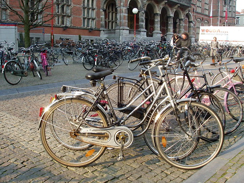
Cycling into the Future Groningen undoubtedly leads the way in the “cyclisation”of European cities, but many others are putting two wheels in motion to follow its example. However, no other European city can match Groningen’s record, where 57% of all trips around the city are on bikes, but in quite a few cities the ratio is rising to a third or more.The impressive high rate of cycling in Groningen can be explained best by consistent urban development and transportation policies based on reclaiming inner city space from cars, making it into a living room for its people. This spatial concept of city develop-ment has undoubtedly been rooted in the clear political vision of the Social Democrats for several decades. Such legislative commitments do seem to be the key in getting citizens to kick the car habit. Apart from a political vision, many other actors involved in making Groningen the “World’s Cycling City”cannot be ignored – the cyclists themselves. In a nutshell, the success of cycling in Gron-ingen can be explained as a result of a strong vision for a liveable city for its people.  For more information, please visit: http://www.cyclinginfo.nl/ and http://www.fietsberaad.nl/
The centre of the city was to be considered as the ‘living room’for its people”
Photo courtesy of  http://www.flickr.com/photos/truusbobjantoo/2404090966/

Wednesday, September 28, 2011

New York City Mandates Street Retail

From William H. Whyte's Book, City: Rediscovering the Center (1988).
Appendix B

Mandating of Retailing at Street Level

In the 1975 tightening of requirements for open-space bonuses, the New York City Planning Commission took a first step toward banning blank-wall frontages. It required that as a condition of the bonus at least 50 percentage of the frontage on the plaza be devoted to retail uses.

In the 1982 revision of midtown Zoning, the commission went further. It required that all of the frontage on retail streets be used for retailing, whether there was a bonus or not. Stores had to be accessible from the street and the glass fronts had to be of transparent glass.

Below is the commission's "plain English" explanation, and the abridged text.

81-42 Retail Continuity along Designated Streets
The vitality of retail commercial streets depends upon a continuous row of retail establishments which can draw pedestrian shoppers along the length of the street. Areas occupied by open space or non-retail uses can interrupt the flow of shopping pedestrians and impair retail activity along nearby frontages The provisions of this section are designed to protect the retail activity along designated streets by restricting ground floor occupancy to those commercial uses which will enhance the existing retail character.

Abridged Text
81-42 On designated retail streets . . . a building's street frontage shall be allocated exclusively to [retail, personal service, or amusement] uses . . .
Museums and libraries shall be permitted . . . Store fronts for the permitted ground floor uses shall be not more than 10 feet from the street line or, where an arcade is provided with supporting columns at the street line, not more than ten feet from the supporting columns.

In no event shall the amount of street frontage occupied by lobby space or entrance space or a building entrance recess exceed 40 feet.

81-142 On wide street frontages in underlying C5 commercial districts, at least 50 percent of a building's street wall surface shall be glazed and transparent at ground floor level.

New York City Planning Commission, Midtown Zoning (New York, 1982)
Available from the commission at 7 Lafayette Street, New York, N.Y. 10007)

Tuesday, September 27, 2011

Vibrancy amongst the blight


A south Indian restaurant plans
to open where a Korean restaurant
stood just a month ago.

It's no secret that as attention moves north to the proposed San Francisco 49'er stadium and the recent purchase of stadium opponent Great America by the Niners, the historic El Camino Real sinks into blight, poverty, and crime. (49ers owners part of the $70 million deal to buy Great America theme park)

The El Camino Real is increasingly becoming a sad, decaying monument to 60's era sprawl. The Santa Clara strip starts at the local university of the same name meandering to Lawrence Expressway; the overpass being the gateway to Sunnyvale. Containing cheap motels, used car dealers, liquor stores, and homeless encampments, the neglect becomes more apparent every day.


Blight is more noticeable
these days on the El Camino Real.


As the home to the Korean Community in the Silicon Valley, the ECR is littered with Korean grocers, banks, and restaurants. But lately the area is reinventing itself with new business and restaurants; with new Halal butchers. South Indian vegetarian restaurants, and even a new nursery and garden center.

The cheap rents have attracted new restaurants with an Indus flair. Also small independent grocers have opened, bringing much needed weekend traffic.


This Indian restaurant used
to be Italian. From green, white,
and red to green, white, and orange. 


Given that city has no definable destinations; no downtown, no central business district, no cultural center, and no central park (the city's Central Park is actually on the periphery near Cupertino), there is no focal point to the city. Much of what was downtown was torn down in over 40 years ago.


- Posted from my iPhone


Tuesday, September 20, 2011

Upcoming Bike Events in the Silicon Valley - September 21

Upcoming Events in the Silicon Valley

September 21 - Come hear San Jose's Director of the Department of Transportation Hans Larsen speak about Road Diets, Complete Streets and other bike related transportation issues. Come out and show how strong cycling is in San Jose. Hans Larsen, Kim Walesh (Director, Office of Economic Development) and Pierluigi Oliverio (Councilmember, District 6) all have been very understanding and supportive of San Jose Cycling Events.
Wednesday, September 21, 2011 7:00 - 9:00 PM
Willow Glen Middle School Library (near the intersection of Cottle Ave. and Malone Rd.), 2105 Cottle Avenue, San Jose.

September 24 - 3 Events
Campbell Bike Rodeo - Saturday, September 24, 2011- Noon to 4:00 pm
This will be the first Children's Bicycle Rodeo for the Campbell Recreation Center and involves teaching children the importance of bicycle safety through a number of fun obstacles. Children will have the opportunity to learn to yield to traffic, proceed into an intersection, scan back over the left shoulder without swerving and move left only after checking behind to be sure it's safe.
Bicycle & Helmet Donations
Please email us if you are interested in donating a bicycle or helmet suitable for children aged 5 - 12 before Saturday, September 24th.
Volunteers needed for this event: If interested contact Thanh Do at City of Campbell | Campbell Adult Center at 408-866-2147

San Jose's Moving Planet Day Bike Party
Start is Discovery Meadow Park, San Jose, CA
Corner of Woz Way and West San Carlos Street
World-wide, Saturday September 24th is the day to take positive peaceful action to reduce climate change by moving without fossil fuels. We’re doing it in San Jose with an all ages kid-friendly bike party from 11 am to 2 pm! Ride Route (pdf).

San Jose Bike Party Birds will help facilitate the ride.

Let’s meet at 11am at Discovery Meadow Park, at the corner of Woz Way and San Carlos Street. We’ll ride together to the Luna Park Chalk Festival at Bakesto Park take enjoy the Festival and lunch together. Bring your own or buy from the vendors. From Bakesto Park we’ll ride to through Downtown San Jose to Happy Hollow Park & Zoo and then back to Discovery Meadow Park by 2:30 PM.
See Facebook Page for more details.
Tour de Fat 2011- San Francisco - L:indley Meadow Golden Gate Park 10-5


Monday, September 26, SJBP October Test Ride #2 6:30 - 9:30 PM


Friday, September 30, Peninsula Bike Party, 7:30 PM.meet at "the Oval" at Stanford University.

Bike Fiesta and Bike Soiree
Bike Fiesta is part of Bike Soiree, an advocacy inpired "Party on Bikes".  The intent of the rides is to have fun while learning how you can create a better environment for cycling in the Silicon Valley. Rides may include highlights of specific bicycle advocacy issues that have risen to the top of the 'Urgency" list. So come out and enjoy one (or both) of our two rides in the Silicon Valley. The first week (Saturday) of each month will include a ride that is focused on the San Jose area. The second Saturday will include ride covering the Sunnyvale/Mountain View areas as well as those areas to the north.

October 1, 2011: 6 - 10 PM - Bike Soiree - Bike Fiesta pre-Rock n Roll Bike Soiree (Facebook link) @

October 8, 2011- Saturday - 5:30 - 10:30 PM Biketoberfest Bike soiree (peninsula)
Game plan
Tour of great peninsula neighborhoods, perhaps some pubs.... byob too!
------------

Game Plan:
... Meet in dt Sunnyvale - perhaps at Walt's Cycle or Murphy St?
Take the #803 bullet train @ 5:45pm and arrive in San Mateo at 6:14pm
if you want to start from dt SJ, take the (same) #803 bullet train @ 5:35pm
Get off train in dt San Mateo, ride around, maybe grab a bite to eat
about 7:15-7:30pm leave dt SM, head south


--

Saturday, September 17, 2011

Powerful auto dealers flex muscles, White House blinks


Hayward, CA
One of the many abandoned

auto lots I encountered on
 a recent bike tour in the East Bay.
 In a September 15, 2011 Wall Street Journal article titled "Dealers Oppose Gas Rules, the author describes a renewed sense of power from a recent backdown from the White House. The article opens by stating,

The nation's politically influential automobile dealers, emboldened by the Obama administration's recent retreat on tougher smog regulations, are revving up a lobbying effort to block fuel-economy rules proposed by the administration
This week over 400 automobile dealers will descend upon Washington to block and delay the introduction of rules seeking to improve the nation's fuel efficiency standards on automobiles for at least one year. Congressional member Steve Austria (R., Ohio) sponsored legislation that has already been approved by the House Appropriations Committee that would delay the drafting of the new rules for another year.

The Republicans claim that proposed Obama regulations will burden business at a time when unemployment continues to hover above the 9% level. Democrats although seeking to increase fuel efficiency standards while improving air quality through the new regulations have seen the administration back down twice before. NADA (National Automobile Dealers Association) has previously succeeded twice in getting congressional Democrats defy Obama on key automobile related legislative votes.

San Pedro Square Market


San Jose Eats actually about 10 food trucks
line up on West Saint John Street to celebrate
the opening of San Pedro Square Market. 
As part of several "soft" openings the developers os San Pedro Square Market hosted San Jose Made/San Jose Eats. San Jose Made consists of mostly T-shirt and ball cap vendors. I don't quite get it beacause none of the T-Shirts and hats said "Made in .....San Jose, California, or even made in the USA".

I tried some 5-spice pulled pork off of one of the food trucks and it was fantastic. I didn't get a chance to try some ice cream off of the Treat Bot truck but I have had some before it it is always good.


Bicycle Parking was
non-existent at today's event.

Two things that need to be addressed but is so typical of San Jose events, you keep asking why. Why is it always this way.

The first is the ever present and public show of police in this town. I spotted two pedestrian officers and one on a bicycle for a peak crowed of about 800 people. Later on it dwindled down to about 400 people mostly couples or family members.

I've often been to San Francisco's largest farmers market at the Ferry Building. The market is always packed with at least over ten times as many visitors and I have yet to see one police officer. It seems as though any public gathering requires some type of police presence in San Jose. I'll have to investigate further as to the severe requirements. At least the cops were on foot and not in cars.
This doesn't need to happen.
SF Farmers Mkt. has
free valet parking.


The second item that needs to be addressed is the need for bicycle parking on West Saint John Street. As you can see from the pictures, adequate parking is lacking. Given that this is intended to be a prime downtown location it doesn't make sense that the city didn't require the developer to construct adequate parking before issuing an occupancy permit. So please contact the developer, contact the San Jose Downtown Association, the District 3 (downtown) Councilmember and ask why they were issued building permits and made no requirements for bicycle parking.

So to summarize; too many cops not enough bike racks. Other than that a nice time was had by all.


- Posted from my iPhone

Friday, September 16, 2011

Toyota's Mea Culpa - fund industry safety research


Toyota announced on Wednesday that they will be partnering with leading universities in automotive safety studies. Toyota is stepping up research partnerships with several U.S. universities to study increasingly important safety issues facing the auto industry. This was prompted by public and congressional backlash after series of deadly accidents caused by stuck accelerators (later proven to be caused by poorly designed floormats). Toyota's Collaborative Safety Research Center (CSRC) announced that they will spend $50 million over the next five years to "better protect the most vulnerable traffic populations, including children, teens, seniors and pedestrians."

This announcement comes after congressional, media, and public scrutiny on the heels of the widespread safety and quality issues during 2010. Toyota has vowed not only to take on the cost of the research but also to share it with others in the auto industry. It is interesting to note the new found willingness on the part of Toyota to not only bring their research out in the open but their willingness share it with the industry after spending $50 million for the academic partnerships. Given Toyota's previous reluctance to share safety data this is a big departure from the past.

In the Wall Street Journal version of this story reporter Neil Boudette picks op this gem of a quote;

"Twelve teens die each day in accidents," said Tina Brunetti Sayer, an engineer at Toyota's Collaborative Safety Research Center, the group set up to work with outside institutes in North America. "That's 5,000 a year. This is a group that really needs help in learning to drive."
Did you catch that, "this is a group that really needs help in learning to drive." The engineer assumes that all teenagers drive and secondly that these deaths could be stopped or mitigated by giving driving education "help" to these teens.


Here is an abbreviated list of the universities that Toyota will be collaborating with allong with the reasearch outline.

The Transportation Active Safety Institute at Indiana University/Purdue University Indianapolis
· Pedestrian Pre-Collision Systems (PCS) Test Scenarios
A five-year study to develop testing protocols for automotive PCS designed to prevent pedestrian-related car accidents. The study will draw on available crash data in NHTSA databases and original vehicle testing to develop more sophisticated and realistic test scenarios for PCS with the goal of improving pedestrian safety.
Note: In the Wall Street journal article the author additionally states that; "Indiana University and Purdue University also are developing radar and camera technology to prevent collisions with pedestrians"

University of Michigan Transportation Research Institute
· Posture, Body Shape, and Seatbelt Fit in Senior Drivers
An 18-month project to study the relationship between age and seated occupant posture, body shape, and seatbelt fit. The project seeks to determine if senior drivers and passengers sit differently in the vehicle, to characterize exterior body shape changes that occur with age, and to understand how these factors influence seat belt fit. The statistical models resulting from the study can be used to better understand senior occupant kinetics and injury patterns in a crash event.

Wake Forest School of Medicine
· Advanced Automated Crash Notification
A one-year partnership to develop vehicle computer systems that not only notify first responders in the event of a collision, but also predict the likelihood and severity of occupant and driver injuries.
Note: This sounds like an medical engineering nightmare. Sensors in your car will determine the extent of your injuries and relay this information to the first responders. This however will not be avaiblable to pedestrians, cyclists, and motorcyclists.

Wayne State University School of Medicine
· Driver Distraction: Cognitive Model & Validation
A three-year collaborative study to better understand the cognitive aspect of driver distraction. Combining research in the fields of driver behavior, cognitive psychology, and cognitive neuroscience, the project will advance the auto industry’s understanding of a phenomenon that has been widely blamed for many accidents and injuries on U.S. roads and highways.
Toyota Collaborative Safety Research Center Announces 10 New Projects and Six New Partnerships With Leading Academic and Research Institutions

Totyota Teams Up For Safety Studies - Wall Street Journal, September 15, 2011

Fatality Statistics - NHTSA FARS National Highway and Traffic Safety Administration - Fatality Analysis and Reporting System

Location:Civic Center Dr,Santa Clara,United States

Wednesday, September 14, 2011

iPhone App Reveiw - SJ Transit Lite


SJ Transit Lite v.2.0 app review, January 20, 2012

After using tranisit systems in such cities as New York, Washington DC, Portland, San Francisco, and Alameda County I was ready to trying an app I had seen on the App Store titled "SJ Transit Lite". Most apps contain some type of "Next Bus" GPS technology (Routesy, IC SF Lite, Transporter for San Francisco) that tells you when the next three busses are estimated to arrive (not the schedules but actual ETAs).

SJ Tranisit has no such technology. This is a transit (light rail and bus) app in the most basic sense. It basically contains timetables and the individual route maps. The app lists the complete line up of trains and busses which numbers close to 90 lines. Scrolling down that long list of routes can be a bit time consuming and mind boggling considering that the app crashes more than half the times it is opened.


Other transit apps have a bookmark feature so that you can mark you favorite stop or favorite line. Not so with this app. You have to scroll down long lists of routes just to pick yours. Also this app only uses the VTA's time tables incorporating the time stops. Time stops are only a few selected stops at the largest intersections. In other apps you can choose a favorite stop and it will show you the published time as well as the expected time for any stop along the way.

Part of the reason that the app is so lacking is that there really is no other competition out there and chances are that this will not change in the near future. In San Francisco there are at least three transit apps (some even with BART and Alameda Transit tacked on) providing enough completion between apps developers. So although this is all there is for VTA it is a true disappointment.


9/18/2011: An update is now available for this app stating that the developer has removed the ads and fixed the problem with frequent crashes. I tried the new version and can say that so far it looks like it's fixed. I still find it sad that he wants to hide other issues by having users email problems to him directly instead of highlighting them in the reviews.

Saturday, September 10, 2011

Janette Sadik-Khan, Bicycle Visionary Creating a Legacy


Frank Bruni a columnist for the New York Times published an Op-Ed in tomorrow's paper titled: Janette Sadik-Khan, Bicycle Visionary. In his view cycling represents a classic chicken and egg problem.
And for that it has received, from some of its citizens, an unwarranted degree of ill-considered grief. Biking, it seems, is an uphill ride, due largely to mathematics and a sort of Catch-22: with only a small percentage of Americans using bicycles as their primary method of transportation, there's no huge public outcry for - or immediate political benefit to - remaking city streets so that they're a little less friendly to cars and a lot more hospitable to bikes.
But without that hospitality, primarily in the form of better bike lanes and more bike racks, biking isn't convenient and attractive enough to win all that many converts and thus a political constituency.
Unless you have a champion for the cause like Janette Sadik Kahn. Under here tenure bike lanes in the New York have doubled since joining the city as DOT director in 2007.

Bruni cites one example of the swift action the city has taken by describe their new bike share (or rental) system. He writes, "The city has also plotted a far-reaching and potentially game-changing public bike share program, whose details and timetable are expected to be announced this month. In a swift manner all the more impressive given government sclerosis these days, New York is truly transforming itself."

And its not just bike infrastructure that has regenerated the life of New York's city streets. Street furniture on Broadway, crosstown express busses, coverd bike parking, and safer street crossings for pedestrians have made locals and tourists alike stand up and take notice. Thank you, Janette.


Bike Corrals making inroads into some U.S. cities

<><>
<><>
<><>
Yarnbombing and bike corrals.
A great combo.
Photo: periwinklecog
One of the ways to get more people on bikes is to have safe convenient places for cyclists to park near shops, restaurants, libraries, and schools. By making the space convenient, shoppers will use bike parking racks that give them priority over drivers. Also, by placing racks in convenient and visible areas, cyclists will visit more often and stay longer if they know there bicycle is parked in a safe spot. Currently such forward thinking cities as San Francisco, New York, and Portland are incorporating bike corrals into business districts.

According to Portland's Department of Transportation (which has now installed 67 corrals in the city) on street bike parking provides some benefits where bicycle use is already high or growing. Some of the benefits are:

  • Businesses: Corrals provide a 10 to 1 customer to parking space ratio and advertise “bike-friendliness.” They also improve the outdoor café seating environment by removing locked bicycles from the sidewalk.

  • Pedestrians: Corrals clear the sidewalks and serve as de facto curb extensions.

  • People on bicycles: Corrals increase the visibility of bicycling.

  • Motor vehicle drivers: Corrals improve visibility at intersections by eliminating the opportunity for larger vehicles to park at street corners.
On street bicycle parking, or bike corrals as they are also called, does this and more. The concept of the bike corral is to take the space of one car and provide as many as 10 to 14 spaces for bicycles. Many times bike corrals are place at the corner of busy intersections to improve safety by using a design technique called "daylighting". High volume business such as coffee shops make perfect spots to locate corrals due to the reduction in traffic volume around such businesses.

What are some areas that could use bike corrals in your city? Does your city have a program to install bike corrals?


View Larger Map

Eyes on the Street: NYC’s First Bike Corral Underway on Smith Street

Portland DOT's bike corral program


Thursday, September 8, 2011

Dinner and Bikes Night

The Emmons Family arrives
on a bicycle built for two,
or maybe four.
Last night was a truly memorable moment in San Jose bike culture. Elly Blue and two of her friends arrived in San Jose as part of their Rambling Road Show. They are in the second week of a five week tour across the western United States and will be arrive back in Portland on October 1 to give their last presentation.  The event was held at Silicon Valley Debug a fantastic art space just north of the Alameda. The folks at SV Debug were excited yesterday just having released their freshly updated website.

Elly arrived with Joe Biel and Joshua Ploeg. All three are some of the most incredibly talented people I have met in a while and that's speaking from the Silicon Valley, the often mentioned center of all things innovative in this world.

Joe Biel is a film maker (not that anyone uses film anymore) and showed us a selection of very short films about bicycle culture and activism, including excerpts from Aftermass, his forthcoming documentary about bicycle activism in Portland, Oregon over the last twenty years. Joe has been part of Microcosm Publishing since he started it in his closet 15 years ago.

Joshua Ploeg is a traveling vegan chef, who improvises climactic culinary masterpieces on two hours’ notice. His book In Search of the Lost Taste is a Microcosm smash hit. He has several cookzines, including the popular Fire and Ice and the brand new So Raw It’s Downright Filthy. Joshua was amazing last night using what little resources he had to whip a multi-course wonder of vegan goodness.

Joshua whipped up an amazing meal
last night for all attendees.

The crew brought with them books, zines, t-shirts, stickers, and other schwag that was amazing. The list of titles from both Microcosm as well as other publishers was extensive. Elly is a writer, speaker, publisher, zinester, and one of the best communitarians I have yet to meet. She currently writes for Grist.org and as of late has written a series of 10 articles relating to bicycle economics. She publishes a blog and a zine, both called Taking the Lane.

I first met Elly while attending a conference several years back. The event was attend by folks from all over the world. This is were I heard or met some key people in the wonky world of transportation policy; Todd Litman from VTI, Andy Clark from League of American Cyclists, Mia Burke author and president of Alta Planning, Gil Penalosa former Parks Director for the City of Bogota, Columbia and the creator of the now ubiquitous cyclovia phenomenon. It was during the final days of the conference that I got to experience Portland's first ever cyclovia (what they call Sunday Streets) event. After hearing Gil Penalosa speak about it and seeing it in Portland for myself I brought the idea back to San Jose under the name Via Velo.

It was good to see the midweek turnout to hear Elly and her crew speak. Outside of the monthly San Jose Bike Party event its difficult in this town to get people interested in anything beyond the actual ride. Advocacy is not on the top of most San Josean's list so to speak. But I was pleased last night to see a interested group of locals wondering what it was like to bike in that big raincloud to the north.

Afterward, several of us did a post dinner ride on a wonderfly warm summer evening through the downtown area. Along the way at 10 o'clock in the evening we met other cylists out enjoying the beautiflul weather. Maybe we are slowing growning into our own bikey culture.  Thanks everyone for the great evening.

Elly sharing wonky talk and making fun!

Post Dinner Ride.


How much does it cost?


With all of the talk lately of drastically reducing costs at the City of San Jose I just got to wondering how much does an average police cruiser costs the city in total equipment costs. Some of the equipment I have notice in today's cars include:
  • The original cost of the car.
  • Add-ons such as suspension and engine enhancements.
  • Paint and lights (light bar and spot)
  • New back seat, cage and handles and locks.
  • Radios and computers
  • Shotgun and secure holder
  • GPS and camera pod (lately I have seen large camera pods on top of the light bars on some units).
  • Trunk Contents- Accident Response Kit, Defibrillator, First Aid Kid
Police Trunk Organizer Storage Bag by Uncle Mikes If anyone knows the answer to this or knows if I left out any squad car add-ons let me know. I figure an accuracy of about $5,000 up or down show be reasonable enough. Any guesses?

New Amtrak iPhone App


Last month (August 3rd to be exact) Amtrak released it's first iPhone app. In one month's time it's received 92 reviews, many of them highly favorable. Many of the reviews praise this free app for its ease of use and also the ability to update the user's iPhone calendar. Others criticize the app's propensity to crash. I can say that I have experienced only one crash in the many times that I have used this app, but I can honestly say that I absolutely love it. I have made reservations up until 12 hours before departure with no problems.
Here is a list of many of the great things I love about the app.
  1. The look and GUI (graphical user interface) is great. Easy to use the first time.
  2. The ability to save (or bookmark) multiple stations.
  3. Instant confirmation with the ability to create a calendar reminder.
  4. Station information for all domestic stations
  5. Easy integration with Amtrak California.


Although I think this is a great step by Amtrak here are some fixes that I believe would be helpful in subsequent releases.
  1. Saved payment data option. User has to re-enter payment information each time.
  2. Some users have complained about the time zone issue, but I have only used in Pacific Daylight Time so far and haven't had any issues.
  3. Not easily integrated with Amtrak's reward program.
  4. Not easily integrated with Amtrak's discount program.
  5. The "Rewards" and "Discounts" badges (since they are not used as frequently) take up valuable screen real estate at the top of the screen.
  6. Integration with Amtrak's or Amtrak California's Twitter accounts would be great.
  7. It would be nice if the train status section was live or interactive using GPS. Train status seems to be just reformatting the train schedules.
  8. A U.S. route map.
  9. A section similar to station descriptions that would describe onboard bicycle policy and also a section (or a link) describing bedroom accommodations.

It would be great to have a paperless check in system so I didn't have to insert my credit card into their station kiosk but this is a minor detail in a great app/system. Given all of the federal security issues (IDs and ticket signing) that are counter to customer convenience I still think they've done a great job.


- Posted using BlogPress from my iPhone

Monday, September 5, 2011

Bioswales for Emeryville


Emeryville has made some major investments in complete streets. On the way to the Emeryville Amtrak station this morning I caught some glimpses of bioswales, bulb-outs, and redirects.


Bioswales serve two functions; to filter stormwater runoff and as a measure of traffic calming. Bulb-outs or curb extensions narrow
the gap that pedestrians are required to cross while also calming traffic.


Lastly, redirects also prevent exessive or non-local cut-through traffic from excessive use of neighborhood streets. Typically bicycles and pedestrians are allowed access as the picture shows (Salem St. at 47th).


View Larger Map


- Posted using BlogPress from my iPhone